 Image
Image
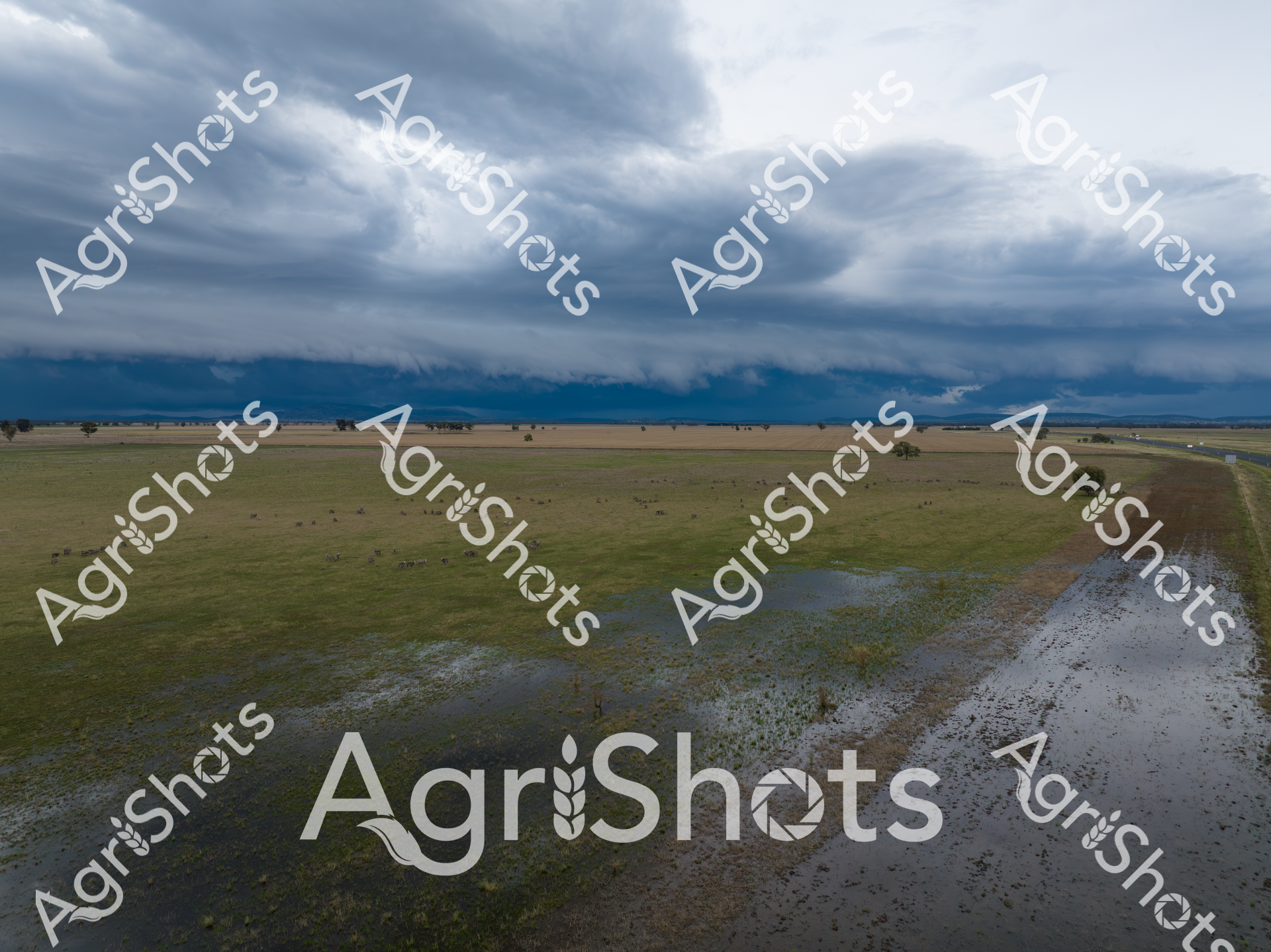
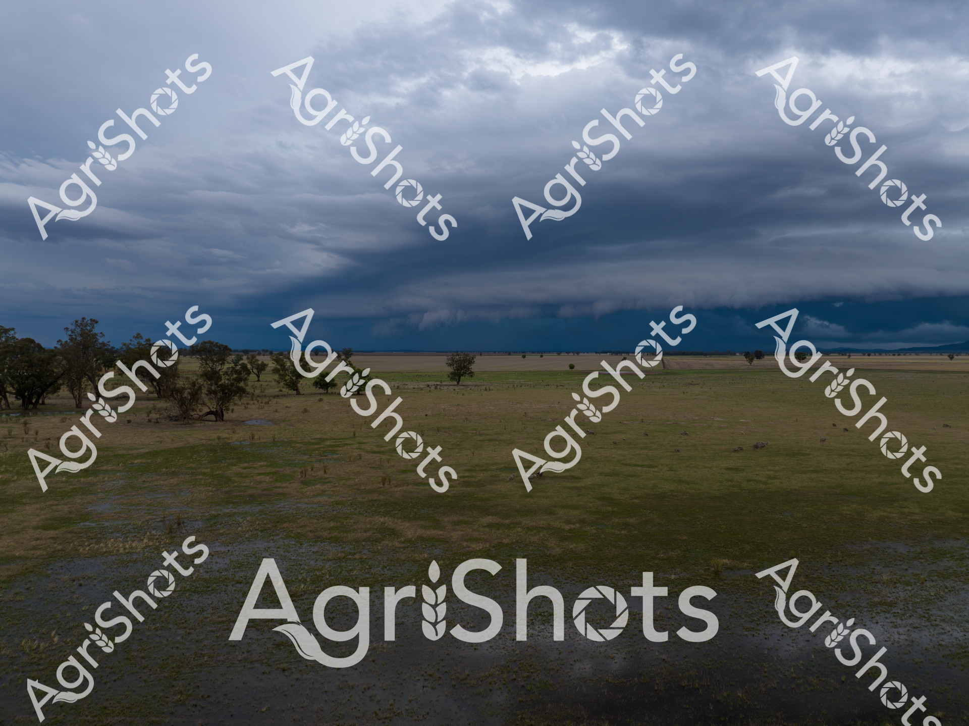
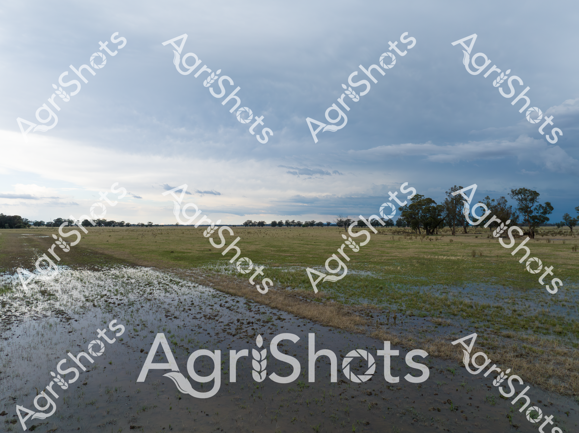
Turbulent storm clouds gather with menacing intensity over the waterlogged Riverina plains, transforming the pastoral landscape into a dramatic tableau of elemental power. Floodwaters spread across the grasslands, creating silvery pools that reflect the heavy, slate-gray sky and interrupt the verdant pasture. Scattered trees stand as silent sentinels amid the inundated grasslands, their resilient forms a testament to the harsh yet beautiful Australian agricultural environment. The aerial perspective reveals the immense scale of the natural event, where water and land merge in a fluid boundary, highlighting the unpredictable challenges faced by farmers in this region. Soft green and gray tones dominate the scene, creating a moody, almost contemplative atmosphere that speaks to the cyclical nature of drought and deluge in the Australian agricultural landscape. This powerful image captures the raw, unfiltered essence of rural New South Wales during a summer storm, where the landscape is simultaneously vulnerable and defiant.
 Image
Image
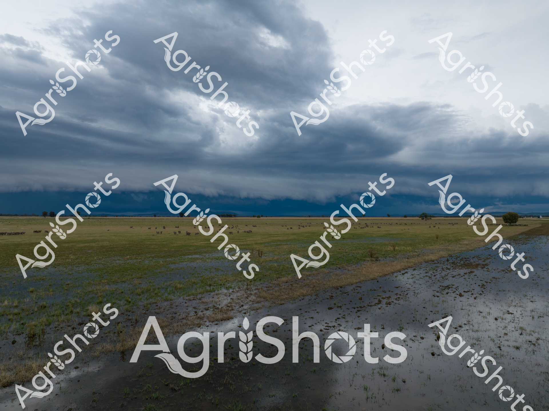
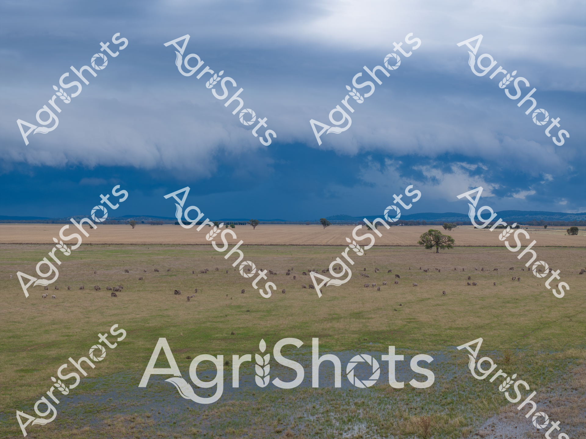
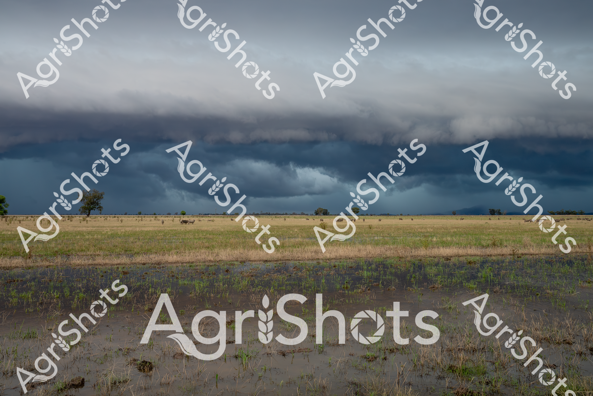
Thunderclouds gather with ominous intensity over the waterlogged Riverina landscape, transforming the pastoral grasslands into a reflective mirror of sodden potential. Seasonal floodwaters spread across the expansive paddock, creating intricate patterns of submerged grass and shallow pools that shimmer beneath the dramatic slate-gray sky. A scattered flock of sheep, barely distinguishable in the distance, grazes stoically amid the inundated terrain, embodying the resilience of agricultural life in the face of dramatic climatic extremes. The horizon is a study in muted blues and greens, with distant mountain ranges emerging like a soft-edged boundary between earth and turbulent atmosphere. Summer's unpredictable temperament is captured in this moment - a delicate balance between destruction and renewal, where water both threatens and promises regeneration for the land. The scene speaks to the profound relationship between Australian farmers and their environment, where every storm carries the potential for both challenge and hope.
 Video
Video
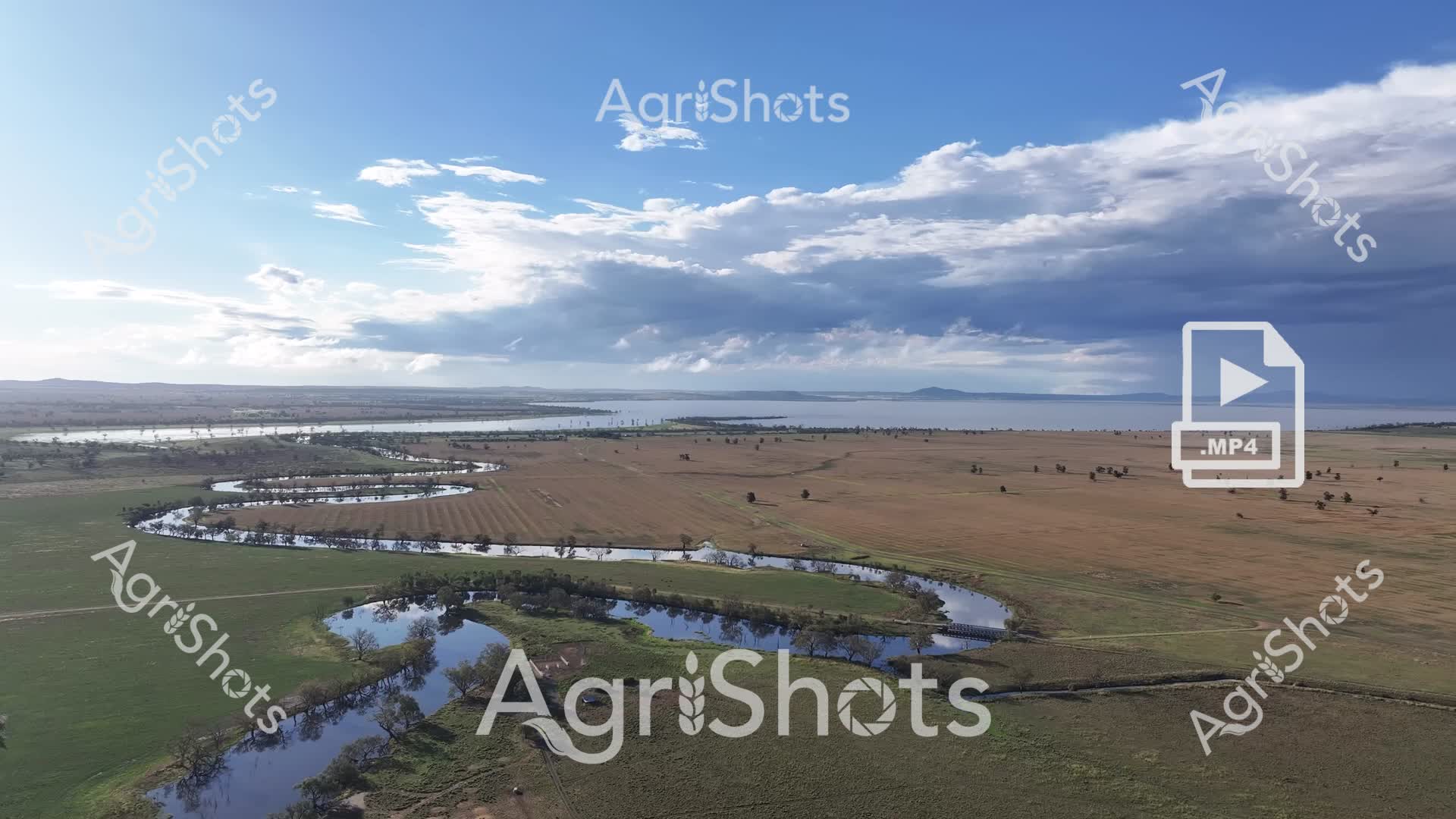
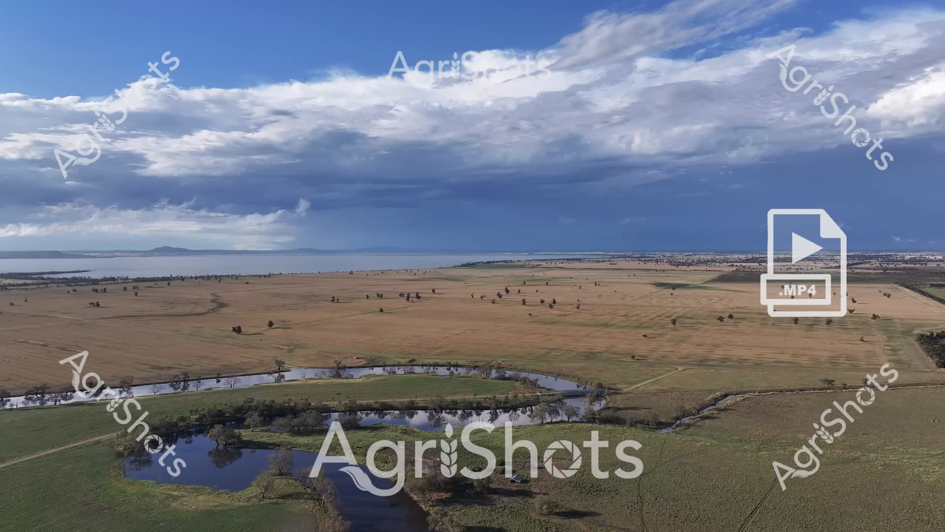
Sweeping aerial vista of the Riverina's expansive agricultural landscape captures a dramatic moment of seasonal transformation. Sinuous waterways curve through verdant green and amber-toned paddocks, revealing the intricate hydrology of this New South Wales floodplain. Scattered trees punctuate the broad horizon, their silhouettes standing sentinel amid the rising waters that reflect the turbulent sky's pewter and azure palette. Billowing cumulus clouds gather overhead, casting dynamic shadows across the undulating terrain and highlighting the agricultural resilience of this challenging environment. The meandering river system demonstrates nature's powerful capacity to reshape and nourish the agricultural ecosystem, with flood waters spreading nutrients across carefully cultivated fields. This panoramic view encapsulates the raw, elemental relationship between water, land, and agricultural practice in the Australian inland, where farmers navigate the cyclical rhythms of drought and flood with remarkable adaptability.
 Image
Image
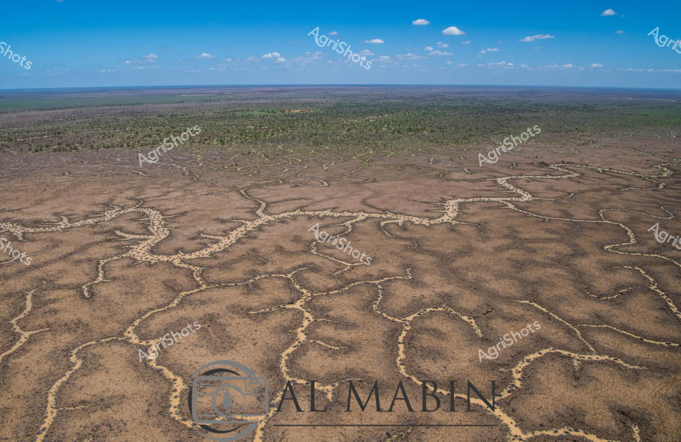
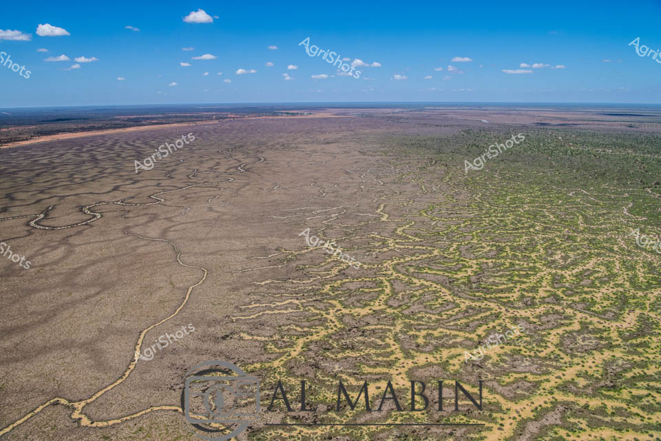
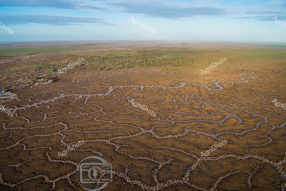
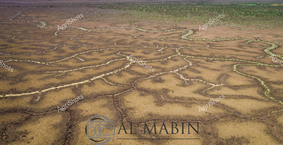
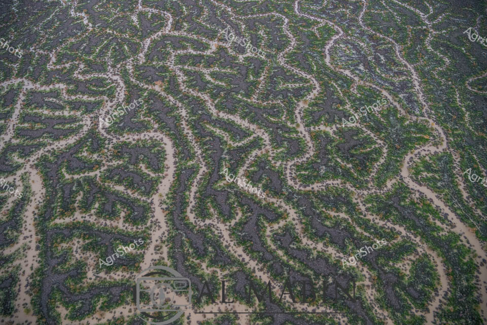
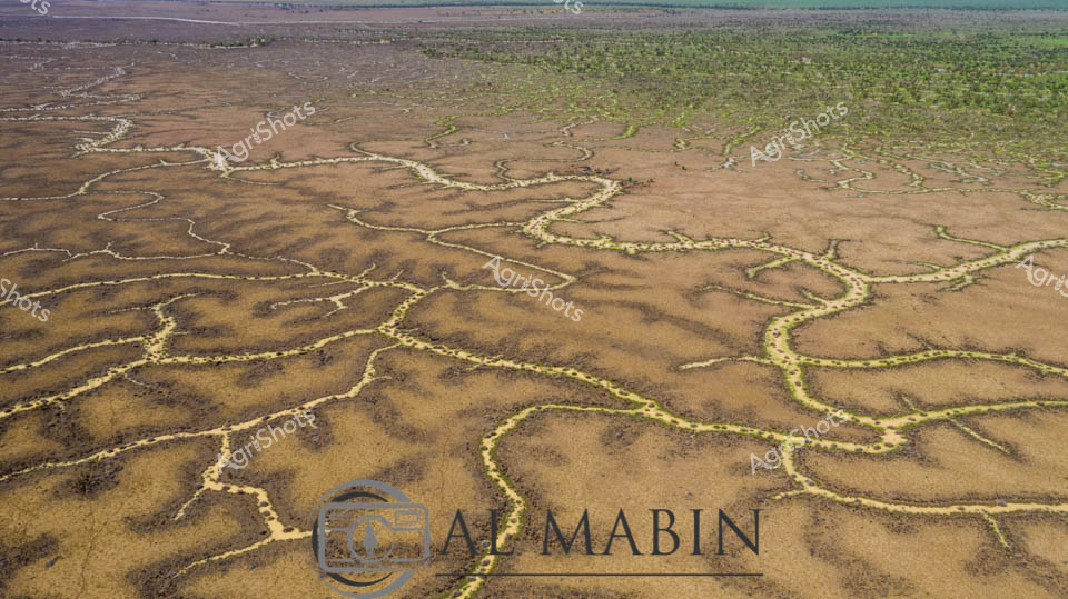
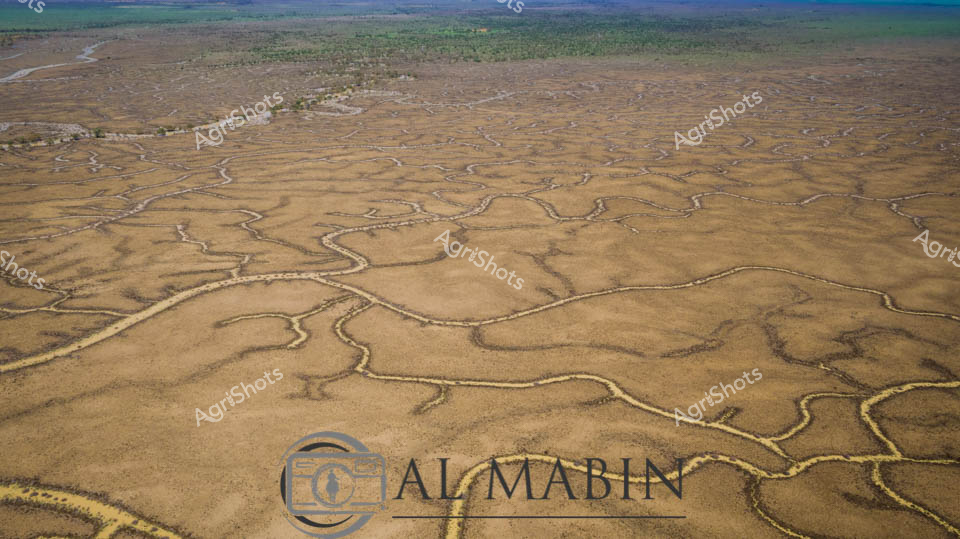
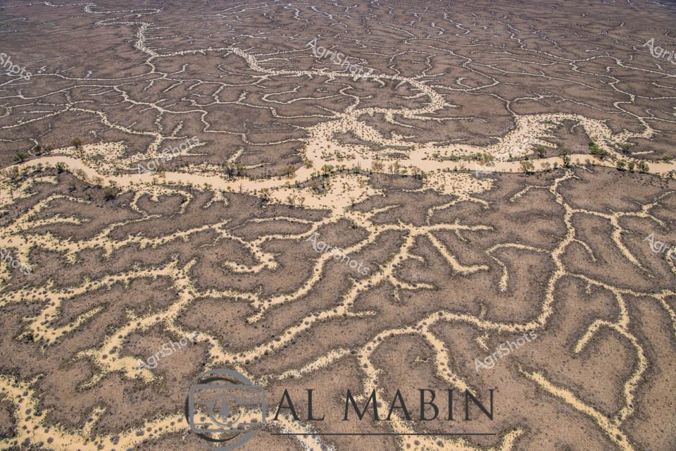
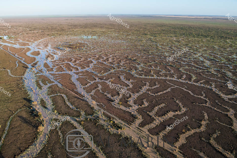
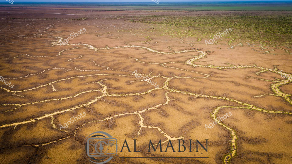
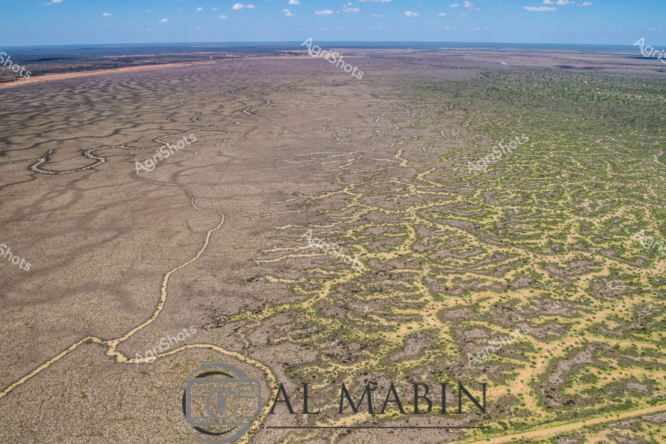
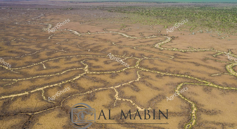
Serpentine waterways carve intricate patterns across the arid landscape of Queensland's Channel Country, revealing the delicate hydraulic infrastructure of Al Mabin station. Aerial perspectives showcase the complex network of ephemeral creek channels, their pale edges contrasting against the ochre and dusty brown earth, creating a natural irrigation system that sustains this remote beef cattle pastoral region. The intricate branching waterways resemble delicate veins across the landscape, capturing the precious moisture essential for survival in this harsh Australian outback environment. Distant green vegetation marks the edges of the floodplain, while a bright blue sky with scattered white clouds offers a sense of expansive tranquility and timeless geological process. This remarkable image captures the nuanced relationship between water, land, and pastoral agriculture in one of Australia's most challenging yet productive agricultural landscapes. The natural drainage patterns demonstrate how strategic water management enables cattle production in an environment where every drop of water is a lifeline.
 Image
Image
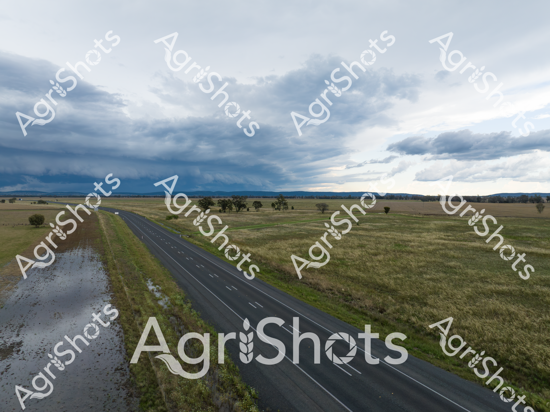
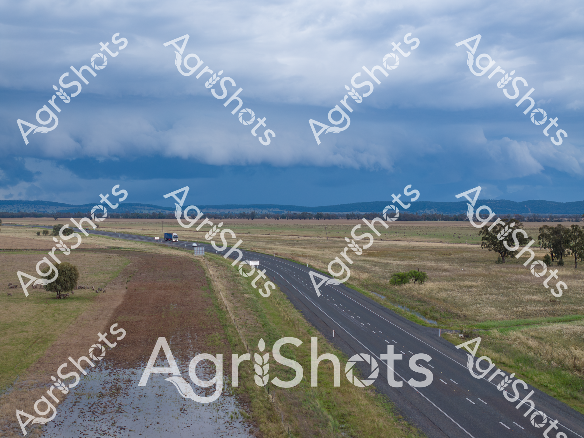
A vast Riverina landscape unfolds beneath brooding summer storm clouds, where an empty highway slices through golden grasslands and scattered eucalyptus trees. Floodwaters pool alongside the bitumen road, reflecting the slate-grey sky and creating a mirror of potential agricultural challenge and renewal. The expansive paddocks stretch toward distant mountain ranges, their undulating terrain hinting at the resilience of this agricultural heartland during unpredictable seasonal transitions. Lush green verges frame the road's dark asphalt, suggesting recent rainfall has nourished the surrounding pastures despite the threatening meteorological conditions. The composition captures the dramatic atmospheric tension of a New South Wales summer, where storms can rapidly transform the rural landscape from parched to saturated. This aerial perspective reveals the raw, elemental beauty of the Riverina - a region defined by its capacity to endure and adapt to extreme environmental fluctuations.
 Image
Image
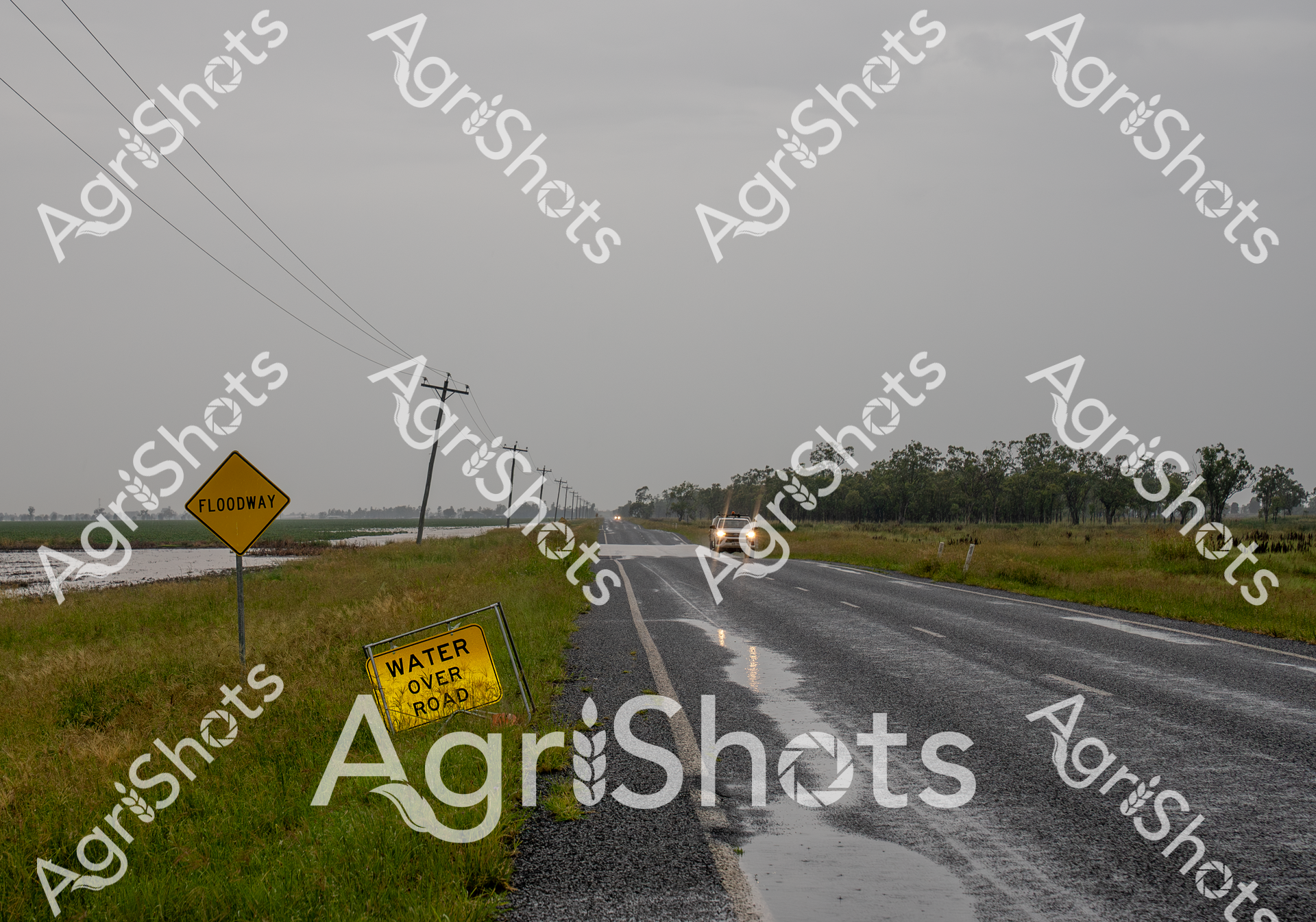
Floodwaters breach the rural highway in Queensland's Darling Downs, transforming the landscape into a treacherous waterway. A vibrant yellow "Water Over Road" warning sign stands sentinel beside the asphalt, its urgent message cutting through the monochromatic grey of an overcast day. Electrical poles stretch into the distance, their lines bisecting the sodden grasslands where water has inundated the surrounding agricultural terrain. A lone vehicle navigates the wet conditions, headlights piercing the misty atmosphere, highlighting the persistent challenge of rural mobility during extreme weather events. The saturated roadside and sprawling fields tell a story of nature's unpredictable power, where agricultural productivity can be suddenly interrupted by flooding. This scene captures the resilience of Queensland's rural communities, who must constantly adapt to the dynamic and sometimes unforgiving environmental conditions of the region.
 Image
Image
Aerial vista of Channel Country's mesmerizing landscape near Windorah, Queensland, revealing the intricate hydraulic networks carved by seasonal floodwaters across an expansive arid terrain. Serpentine waterways branch and meander through the dusty ochre plains, creating complex dendritic patterns that pulse with life-giving moisture across the seemingly barren landscape. The image captures the extraordinary resilience of Australia's inland geography, where ephemeral creek systems transform dry grasslands into temporary wetlands during rare flooding events. Subtle gradations of brown, tan, and muted green reveal the delicate ecological balance of this harsh yet breathtaking environment, where water is the critical architect of survival. Wispy clouds drift across a brilliant azure sky, providing a luminous backdrop to the textured ground below, highlighting the dramatic contrast between aridity and potential abundance. This landscape epitomizes the dramatic seasonal transformations of Queensland's remote beef station country, where water's momentary presence sculpts the very essence of the terrain.
 Image
Image
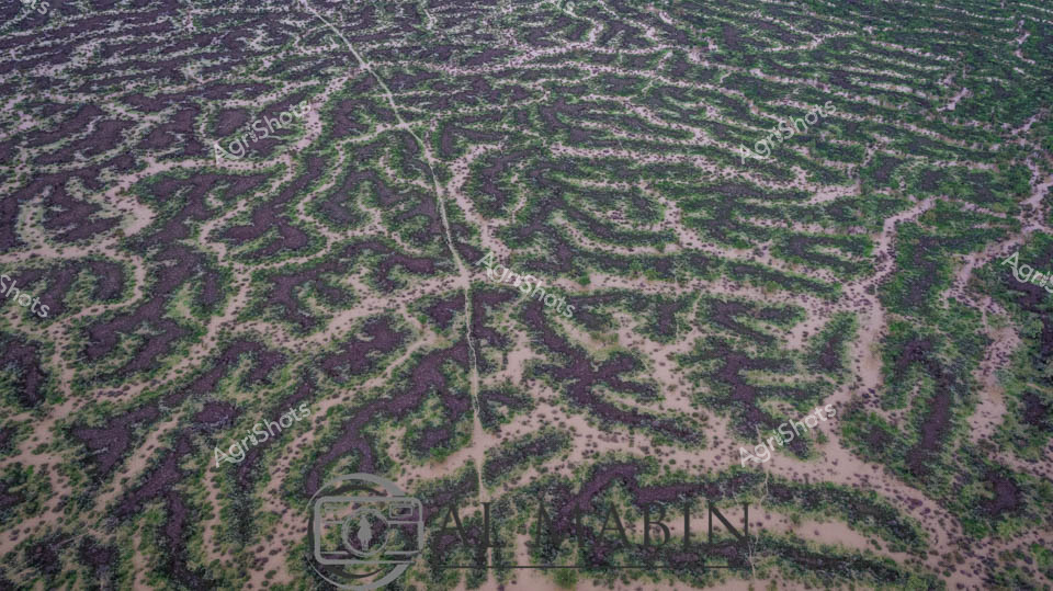
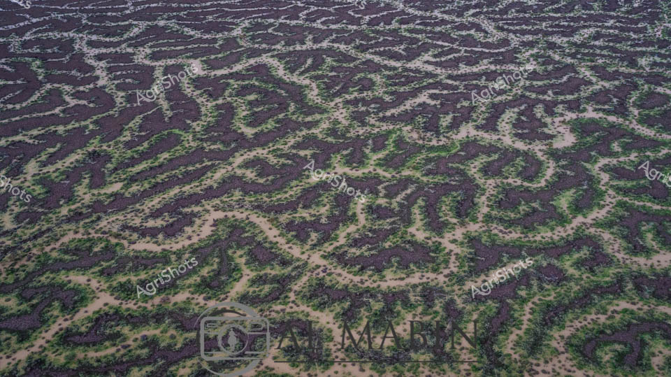
Aerial view of an intricate agricultural landscape revealing the ingenuity of land management in Queensland's Channel Country. Precision-engineered contour banks trace mesmerizing organic patterns across the terrain, creating a living topographical map of sustainable farming practice. Deep purple-brown soil alternates with verdant green vegetation, forming sinuous lines that follow natural gradients and water management principles. These carefully constructed earthworks prevent erosion, manage water flow, and optimize soil moisture retention in this arid agricultural region. The landscape resembles an abstract painting, with methodical human intervention harmonizing with the natural undulations of the terrain. Each curved bank represents a strategic approach to regenerative agriculture, transforming challenging dry landscapes into productive agricultural systems that respect the delicate ecological balance of inland Australia.
 Image
Image
A brooding summer storm sweeps across the Riverina landscape, transforming the agricultural plains of New South Wales into a dramatic tableau of natural power. Floodwaters encroach on the highway's edge, creating a stark contrast between the dark, rain-soaked agricultural fields and the pristine asphalt ribbon cutting through the rural terrain. Dramatic cloud formations stack heavy and deep blue-gray, promising imminent rainfall that will nourish and challenge the surrounding farmlands. A lone semi-trailer traverses the highway, a solitary figure of human resilience against the expansive, waterlogged grasslands punctuated by scattered eucalyptus trees. The scene captures the raw beauty of Australian agricultural country - at once vulnerable and robust, where the landscape's mood can shift rapidly between drought and deluge. Water pools in the foreground, reflecting the turbulent sky and highlighting the precarious balance of moisture that defines farming life in this dynamic region.
 Image
Image
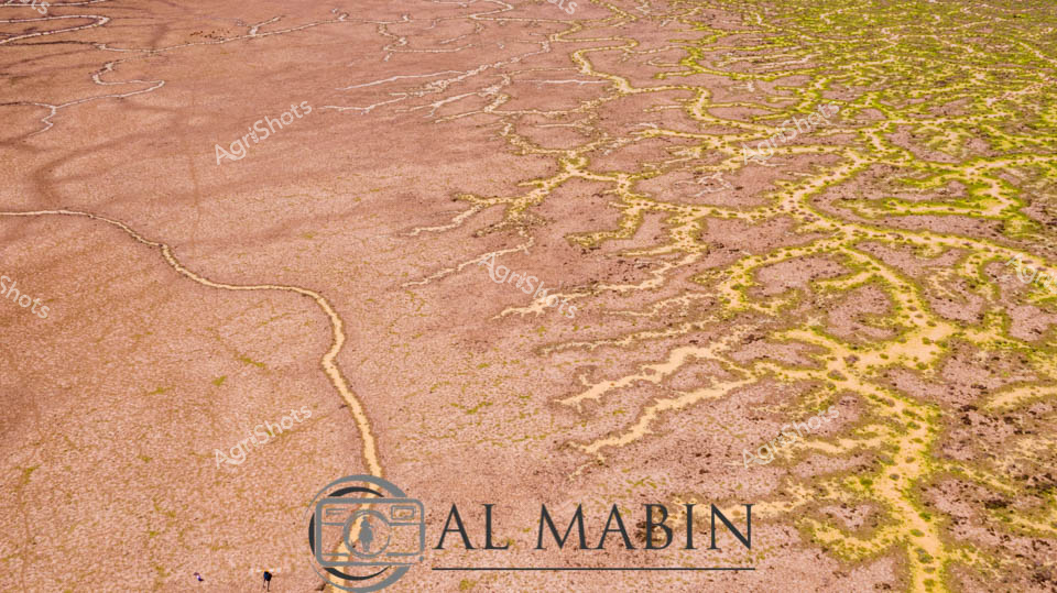
Serpentine waterways thread through the arid Channel Country of Queensland, capturing the ephemeral beauty of this remote pastoral landscape. Intricate river channels meander across the ochre-brown earth, creating a complex network of water tributaries that pulse with life during seasonal flood events. The aerial perspective reveals the stunning geological artistry of natural water distribution, where each sinuous channel carves delicate pathways across the expansive floodplains. Sparse vegetation in muted greens and yellows punctuates the broader landscape, highlighting the resilient ecosystem of this harsh yet magnificent Australian outback region. Soft blue skies with gentle cloud formations stretch endlessly above the terrain, providing a luminous backdrop to the earth's remarkable hydological patterns. This extraordinary landscape represents the lifeblood of beef stations in Queensland's remote interior, where water management and natural flooding cycles are critical to sustainable pastoral agriculture.
 Image
Image
A sweeping Riverina summer landscape unfolds beneath a dramatic cloudscape, where threatening storm clouds gather with intense blue-grey hues above a vast, undulating pasture. Scattered livestock dot the expansive paddock, their dark silhouettes creating a sparse, rhythmic pattern across the muted green and tan grasslands. Isolated eucalyptus trees punctuate the horizon, their weathered forms standing resilient against the imminent weather system. Seasonal flood waters pool in the foreground, reflecting the turbulent sky and creating a luminous blue-green margin that hints at the region's cyclical agricultural rhythms. The scene captures the raw, elemental nature of the Riverina - a landscape of profound openness, where pastoral enterprise meets dramatic atmospheric conditions, revealing the resilience of both the land and those who work it. The image breathes with a sense of anticipation, the approaching storm promising both potential challenge and necessary renewal for this agricultural ecosystem.
 Image
Image
Aerial view of an intricate natural waterway system winding through the arid Channel Country of western Queensland, revealing the complex hydrology of this remarkable landscape. Sinuous green-edged channels break through the dusty golden-brown earth, tracing delicate networks that resemble capillaries across a vast, sun-baked terrain. These ephemeral creek lines, characteristic of the region's seasonal flooding patterns, demonstrate the resilient ecosystem of Australia's inland waterways, where brief moments of rainfall can transform seemingly barren landscapes into thriving, interconnected waterways. The image captures the fragile balance of water and land in one of Australia's most challenging agricultural environments, where pastoral stations rely on these natural water distribution systems for livestock survival. Subtle variations in earth tones - from pale ochre to rich sepia - highlight the textural complexity of the landscape, while the thin green margins of vegetation hint at the life-giving potential of these intermittent water courses. The Al Mabin watermark signals this as a professional aerial documentation of Queensland's extraordinary natural geography.
 Image
Image
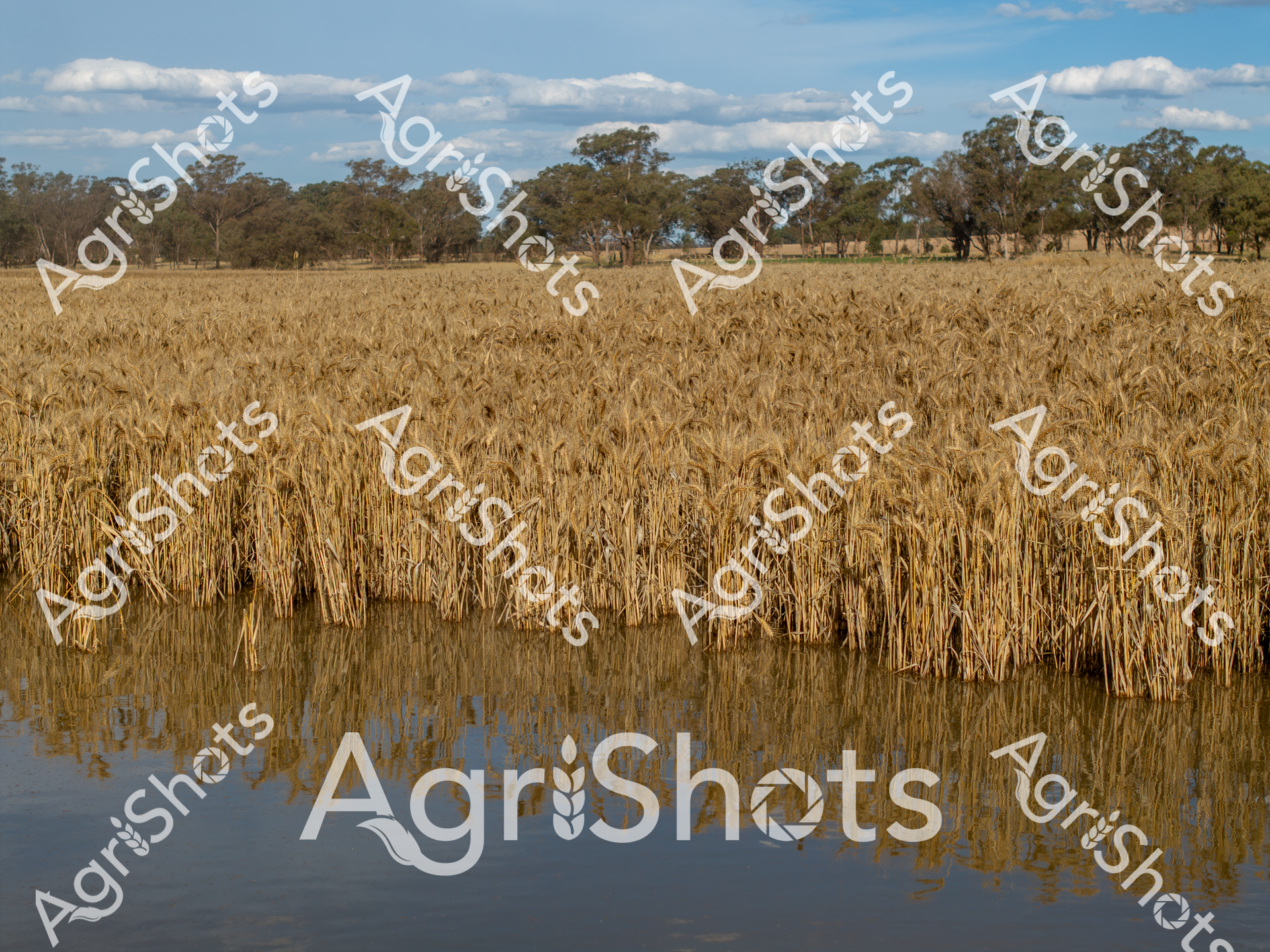
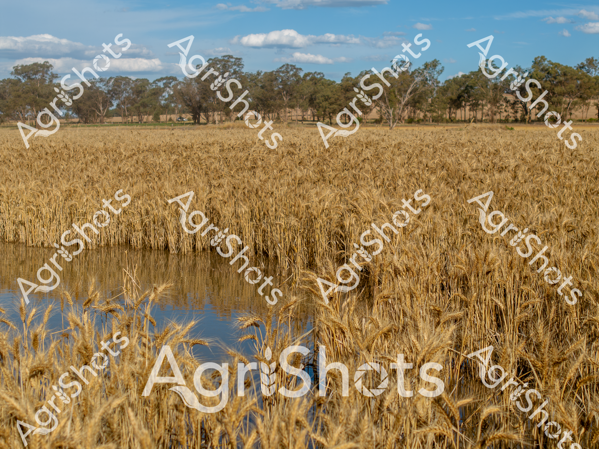
Rippling wheat fields stretch across a luminous New South Wales rural landscape, their golden stalks partially submerged in reflective floodwaters. The mature wheat crop reveals the harsh realities of summer agricultural challenges, with water rising along the field's perimeter, creating a mirror-like surface that perfectly doubles the landscape's intricate texture. Mature eucalyptus trees dot the background, standing as silent witnesses to the agricultural drama unfolding in the foreground. The wheat's rich amber hues contrast beautifully against a soft blue sky punctuated by delicate white clouds, capturing the resilience and vulnerability of Australian broadacre farming. This image powerfully illustrates the delicate balance between natural abundance and environmental unpredictability, where a promising wheat harvest can be dramatically altered by unexpected water inundation. The precise symmetry between the standing crop and its watery reflection creates a mesmerizing visual narrative of agricultural vulnerability and natural beauty.
 Image
Image
Thunderclouds mass on the horizon, casting an ominous slate-blue shadow across the Riverina floodplain. Scattered gum trees punctuate the waterlogged grasslands, their twisted forms standing resilient against the approaching storm front. Shallow waters reflect the turbulent sky, creating a mirror-like surface that stretches across the low-lying agricultural landscape. The scene captures the raw power of a summer storm in New South Wales, where the delicate balance of drought and flood shapes the agricultural heartland. Remnant puddles and saturated ground tell a story of recent heavy rains, the landscape transformed by water's sudden abundance. The image pulses with atmospheric tension - a moment of climatic drama that speaks to the unpredictable nature of rural Australian environments.
 Image
Image
Aerial view of a mesmerizing floodplain near Windorah in Queensland's Channel Country, where intricate water channels weave across the landscape like delicate silver veins. The serpentine waterways create a complex network of green and grey, revealing the dynamic hydrology of this arid region during a significant flooding event. Sparse vegetation lines the sinuous channels, highlighting the stark contrast between the sandy earth and the life-giving water that transforms this typically dry landscape. The meandering streams demonstrate the incredible natural irrigation patterns that sustain pastoral stations and support cattle grazing in this remote Queensland environment. Each twist and turn of the water channels tells a story of resilience, showing how these inland ecosystems adapt to extreme seasonal variations. The aerial perspective captures the breathtaking complexity of Australia's inland water systems, where every curve represents the delicate balance of water, soil, and sparse vegetation in one of the continent's most challenging agricultural terrains.
 Video
Video
Thunderheads gather with elemental force over the Riverina's expansive grasslands, casting an ominous steel-gray palette across a waterlogged pastoral landscape. Scattered livestock graze cautiously amid the saturated paddocks, their dark silhouettes punctuating the sodden terrain as storm clouds mass menacingly overhead. Intermittent standing water reflects the turbulent sky, creating a mirror-like surface that blends horizons between earth and atmosphere. Sparse eucalyptus trees stand as solitary sentinels, their weathered forms highlighting the dramatic meteorological transition sweeping across this quintessential Australian agricultural environment. The raw, unfiltered power of a developing storm system speaks to the unpredictable climate challenges faced by rural producers, capturing the resilience inherent in agricultural communities. Moisture-laden clouds promise imminent rainfall, a critical yet potentially destructive force in this delicate ecosystem of the New South Wales interior.
 Image
Image
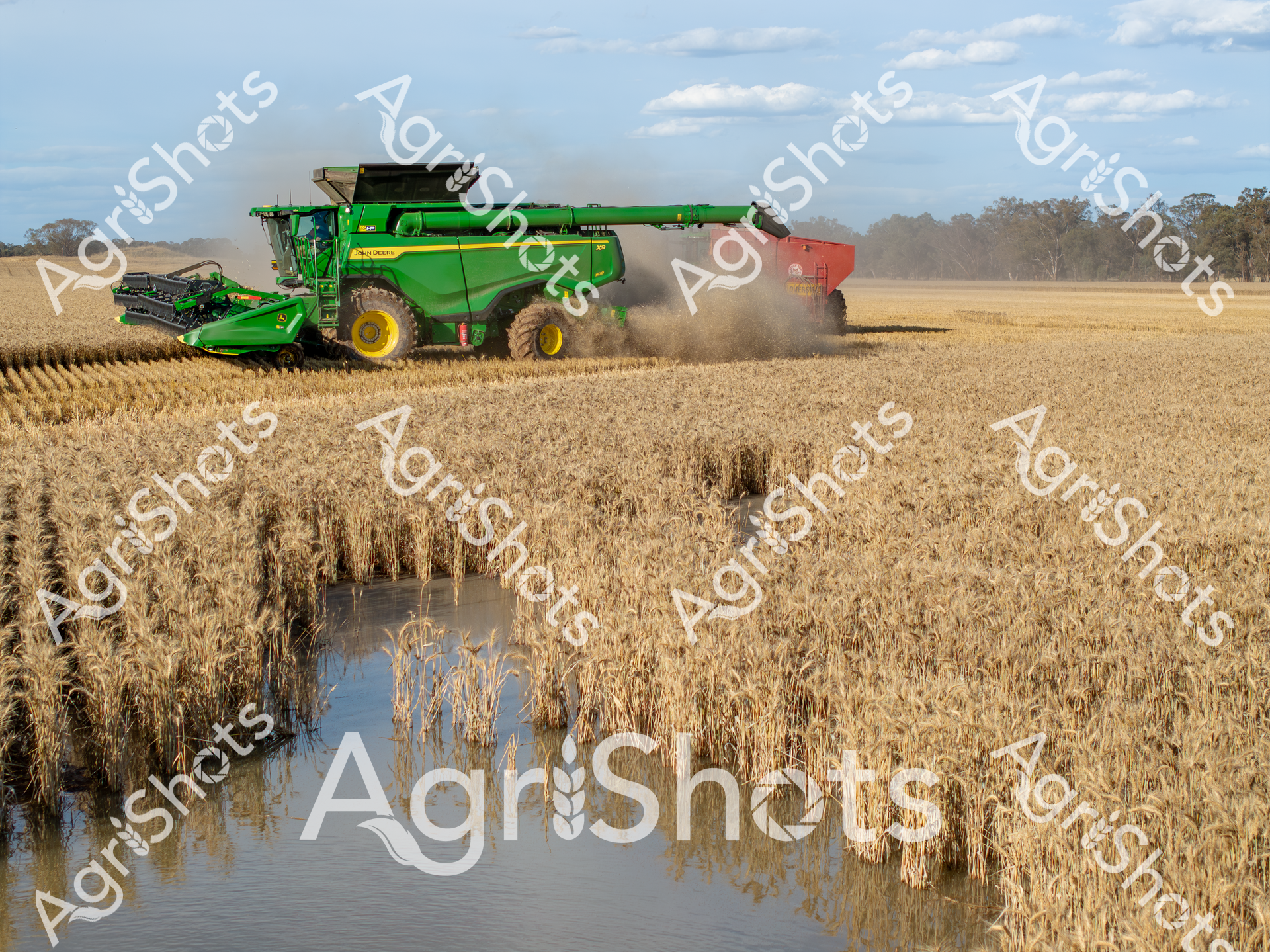
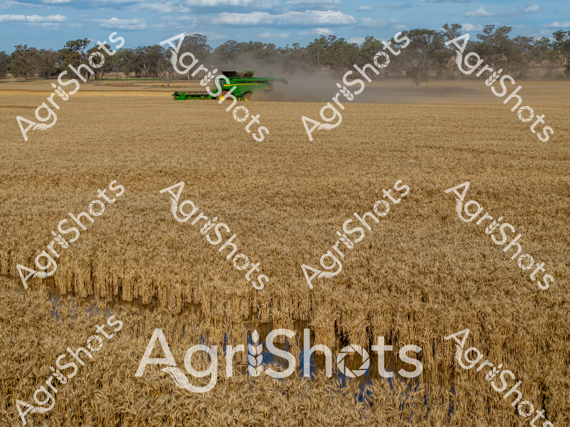
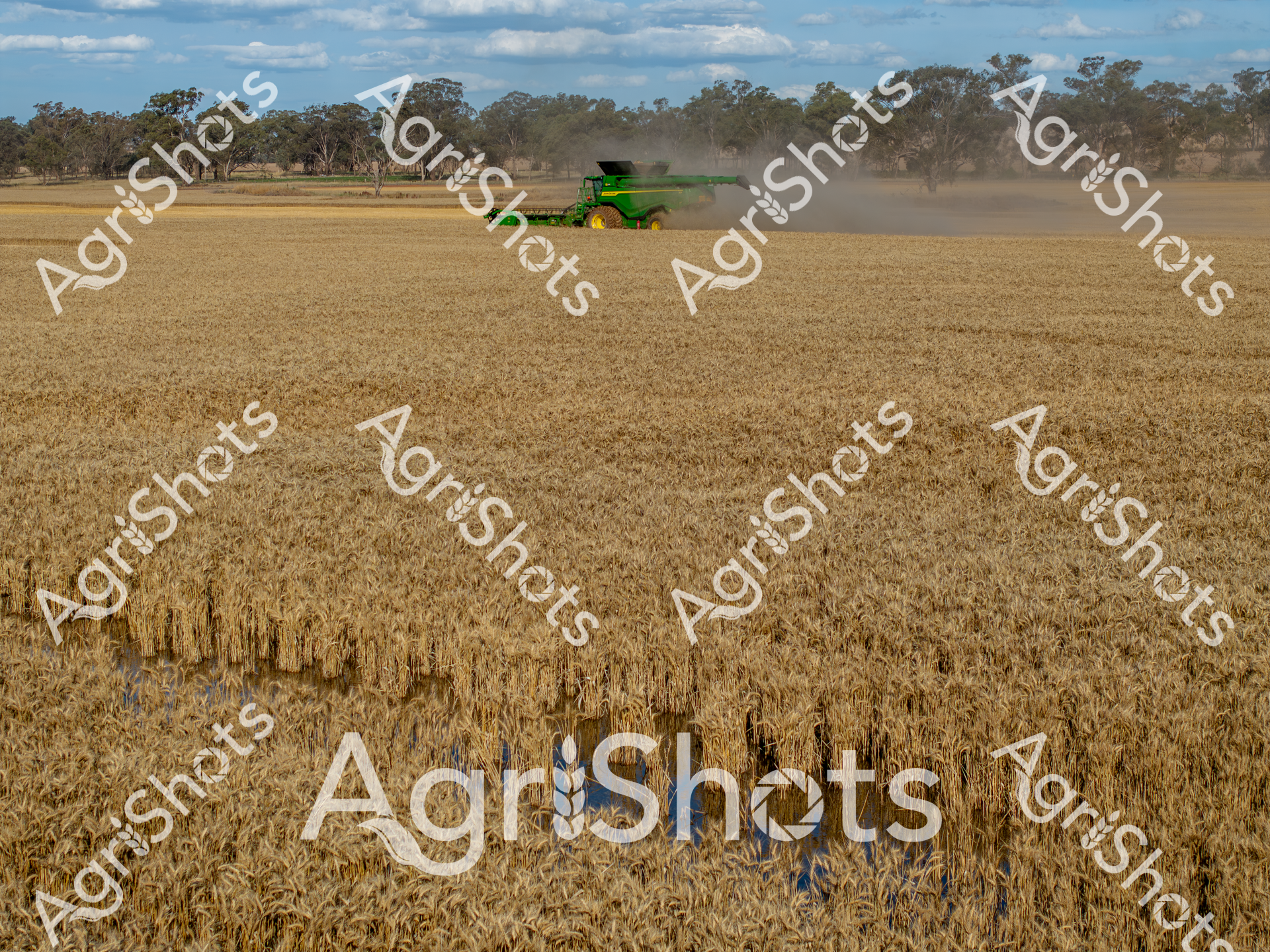
A John Deere header harvests golden wheat beneath a soft summer sky in rural New South Wales, navigating a challenging landscape where flood waters have carved unexpected channels through the ripened crop. The brilliant green harvester moves with precision, its wide cutting deck sweeping across the field while kicking up a cloud of dust, accompanied by a red chaser bin collecting the freshly harvested grain. Wheat stalks stand partially submerged in reflective water, creating a striking visual contrast between the golden crop and the blue-silver surface, highlighting the impact of recent flooding on the agricultural landscape. The machinery's vibrant green and yellow paintwork stands out dramatically against the warm wheat tones and pale blue horizon, capturing the resilience of Australian farming during unpredictable seasonal conditions. Trees line the distant horizon, providing a soft backdrop to this quintessential Australian agricultural scene that speaks to the challenges and technological sophistication of modern grain production. The image embodies both the beauty and harsh realities of farming, where advanced machinery and natural environments intersect in a delicate dance of productivity and survival.
 Image
Image
Serpentine ribbons of golden water wind through the parched ochre landscape of Queensland's Channel Country, revealing the intricate seasonal dance of inland rivers during a rare flooding event. Delicate yellow-green waterways trace meandering paths across the dusty brown earth, creating an extraordinary living map of hydraulic arteries that breathe life into this arid pastoral region. The aerial perspective captures the extraordinary resilience of this landscape, where ephemeral waterways transform seemingly barren ground into a complex ecological system that sustains vast cattle stations and unique inland ecosystems. Subtle variations of tan, amber, and sage reveal the nuanced topography - a mosaic of drought-hardened ground interwoven with rejuvenating water channels that represent the critical lifelines of remote Australian pastoral landscapes. This extraordinary image documents the dynamic hydrology of Channel Country, where water becomes a sculptural force reshaping the terrain and supporting generations of agricultural adaptation. The photograph speaks to the fundamental rhythms of inland Australia - cycles of aridity and abundance that have shaped both the landscape and the agricultural practices of this remarkable continent.
 Image
Image
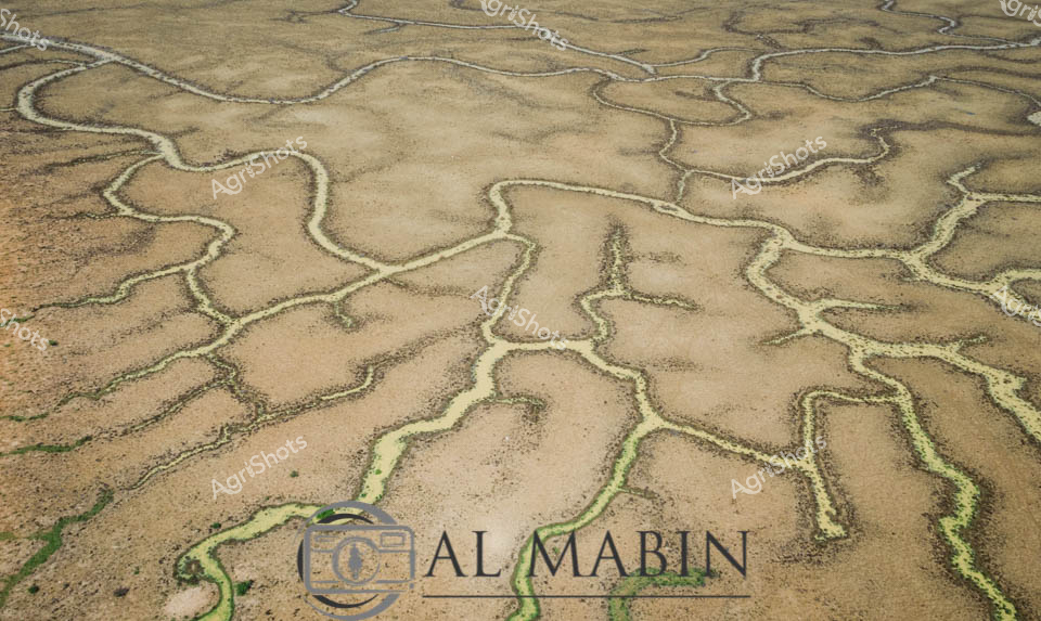
An aerial view reveals the intricate, serpentine waterways of Channel Country in Queensland, where dry creek beds and floodplains create a mesmerizing network of sinuous lines across the arid landscape. The branching water channels, etched into the dusty earth, showcase the complex hydrology of this remote Australian region, highlighting the resilient geography that supports pastoral activities during seasonal flooding. Green vegetation clusters along the horizon, contrasting with the golden-brown tones of the expansive, water-carved terrain.
 Video
Video
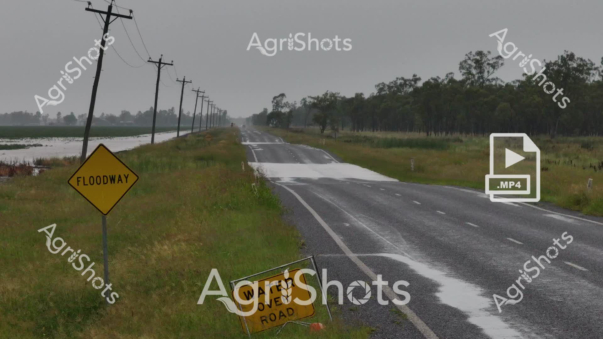
In the heart of Queensland's Darling Downs, a sodden landscape reveals the raw power of summer flooding. A lonely highway stretches into the misty distance, flanked by waterlogged paddocks and electricity lines that march stoically toward the horizon. The yellow "FLOODWAY" sign stands as a stark warning, tilted slightly by the weight of recent inundation, while another sign signals the closure of the wet road. Sheets of water reflect the steel-gray sky, blurring the boundaries between road and surrounding grasslands. Resilient eucalyptus trees line the roadside, their muted greens and grays creating a quintessential Australian rural scene of quiet endurance in the face of natural challenges. This powerful image captures the delicate balance of agricultural life, where farmers must constantly negotiate the unpredictable forces of nature, transforming a potential disaster into a moment of sublime, if somber, beauty.
 Video
Video
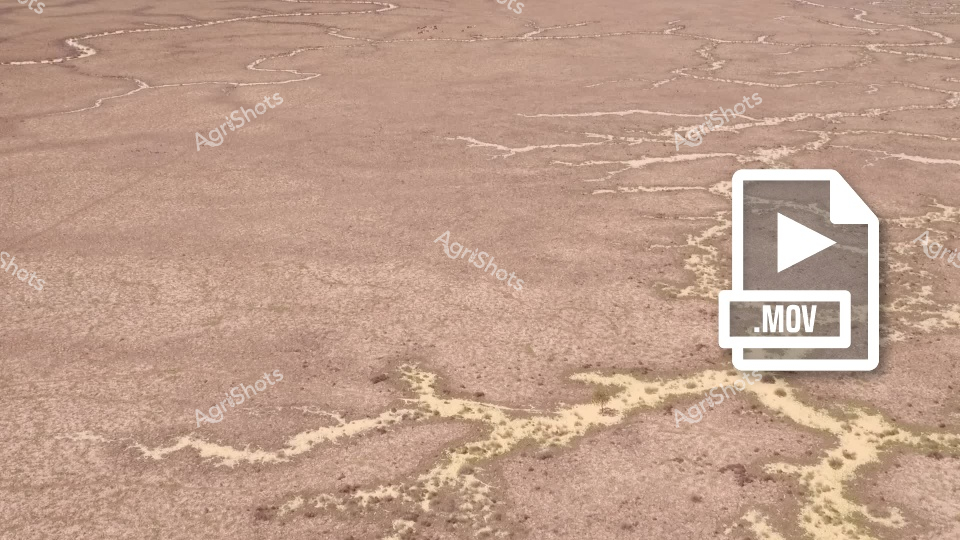
This video footage captures a stark, arid landscape revealing the harsh realities of drought conditions in an Australian agricultural region. The scene presents a parched, cracked earth with intricate, serpentine patterns of dried and yellowed vegetation winding across the barren ground. The color palette is predominantly muted browns and dusty tans, highlighting the extreme dryness of the terrain. The clip appears to document the devastating impact of prolonged water scarcity on a rural landscape, potentially in a region like South Australia or Queensland. Sparse, withered vegetation traces delicate, almost fractal-like patterns across the ground, creating a sense of desolation and environmental stress. These dried vegetation trails contrast against the uniform, baked earth, illustrating the challenging conditions faced by farmers and ecosystems during severe drought periods. The video seems designed to capture the raw, unfiltered reality of agricultural landscapes during water shortages, providing a powerful visual narrative about climate resilience and the environmental challenges confronting Australian farming communities. The stark, minimalist composition emphasizes the profound environmental transformation wrought by extended periods without adequate rainfall. The footage powerfully communicates the vulnerability of agricultural landscapes to climatic extremes, serving as a critical documentation of environmental change and rural adaptation strategies.
 Image
Image
Brooding storm clouds gather with ominous intensity over the Riverina's expansive floodplain, casting a deep slate-blue palette across the waterlogged landscape. Remnant pasture grasses emerge through saturated mud, creating a textured foreground of muted greens and dark earth tones where recent flooding has transformed the agricultural terrain. A solitary tree stands resilient in the middle distance, silhouetted against the dramatic cloudscape, while a few livestock graze cautiously on the marginally drier ground. The approaching storm system presents a powerful meteorological drama, with dense cloud formations layering in shades of gunmetal and charcoal, promising potential heavy rainfall. This quintessential Australian summer scene captures the raw, unpredictable nature of rural agricultural environments, where extreme weather conditions can dramatically reshape the landscape within moments. The image embodies the challenging resilience of agricultural communities in the face of nature's volatile temperament, illustrating both the beauty and brutal uncertainty of farming in the Riverina region of New South Wales.
 Image
Image
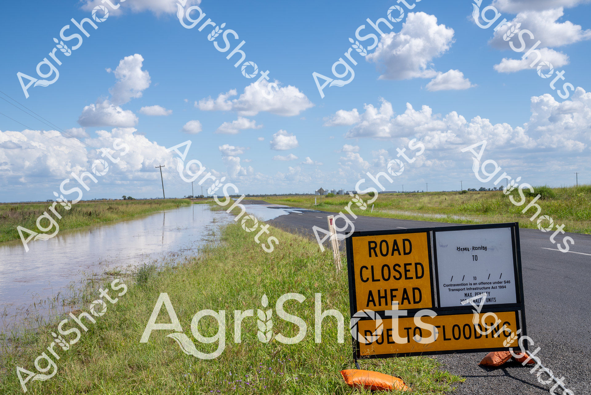
Rural Queensland Flood Inundation: Landscape of Disruption Floodwaters consume the roadway in this stark representation of environmental challenge across the Darling Downs agricultural region. A vivid yellow "ROAD CLOSED" sign stands sentinel at the edge of an asphalt road now partially submerged, its bright warning contrasting against the lush green grasslands and expansive blue sky dotted with billowing cumulus clouds. The landscape stretches horizontally, punctuated by distant electricity poles and the subtle contours of agricultural terrain, revealing the immense scale of water encroachment. Grassy verges blend into the flooded roadside, creating a seamless transition between land and impromptu waterway, while the crisp signage communicates the immediate practical impact of natural inundation on rural infrastructure. The pristine white clouds and brilliant blue sky offer an ironically serene backdrop to the ground-level disruption, highlighting the unpredictable power of seasonal flooding in Queensland's agricultural heartland.
 Image
Image
Aerial panorama of Channel Country's intricate water channels near Windorah, Queensland, revealing the mesmerizing natural irrigation patterns of arid western landscapes. Deep purple-brown earth intertwines with delicate green vegetation, creating an organic, lace-like topography that demonstrates the resilient ecosystem of Australia's inland waterways. Serpentine waterways trace complex networks across the terrain, highlighting the ephemeral nature of water in this challenging environment, where every drop is precious for sustaining pastoral life. The seasonal flooding has transformed the stark landscape into a vibrant, interconnected system of life-giving channels, showcasing the remarkable adaptation of both landscape and agricultural practices to extreme climatic conditions. Soft sandy edges blend with dark soil and scattered greenery, creating a natural camouflage that speaks to the subtle beauty of Queensland's remote interior. This breathtaking aerial perspective captures the delicate balance between aridity and abundance in one of Australia's most distinctive agricultural regions.
 Image
Image
Aerial view of Al Mabin's Channel Country, revealing the intricate network of ephemeral waterways that define this remarkable Queensland landscape. Serpentine channels of pale sand weave through dark earth, creating a mesmerizing natural pattern that resembles delicate river veins across the arid terrain. Sparse vegetation of muted yellows and greens punctuates the landscape, highlighting the resilience of life in this harsh environment. The waterways, etched by seasonal floods, showcase the dynamic hydrology of Australia's inland river systems, where water becomes a transformative force shaping the landscape. These braided channels are critical to the survival of beef cattle stations, providing essential water resources and creating unique grazing corridors in the remote outback. The image captures the raw, elemental beauty of Queensland's remote interior, where water's intermittent presence sculpts a living, breathing geographical masterpiece.
 Image
Image
Serpentine waterways trace delicate green veins across the arid ochre landscape of Queensland's Channel Country, revealing the ephemeral life-giving networks that define this extraordinary inland ecosystem. These sinuous channels—bright emerald against the sandy beige terrain—represent the intricate river systems that periodically flood, transforming seemingly barren ground into a complex biological canvas. The aerial perspective captures the organic, branching patterns of waterways that sustain vast pastoral stations, documenting the remarkable hydrology of Australia's inland rivers during seasonal inundation. Each meandering green line represents a potential lifeline for livestock and native wildlife, highlighting the remarkable resilience of agricultural landscapes in one of the continent's most challenging environments. The Al Marin watermark subtly acknowledges the photographic documentation of this remarkable natural phenomenon, where water creates delicate, ever-changing maps across the expansive Queensland terrain. This image encapsulates the profound relationship between water, land, and survival in Australia's remote interior.
 Video
Video
Storm-laden skies brood over the vast Riverina plains, a dramatic landscape of impending weather and saturated agricultural terrain. Scattered eucalyptus trees punctuate the expansive grasslands, their silhouettes stark against the slate-gray cloudscape threatening imminent rainfall. The pasture displays a palette of muted greens and browns, indicating recent moisture and the potential for flooding across this critical agricultural region of New South Wales. Low-hanging thunderclouds create a moody, atmospheric panorama that speaks to the unpredictable nature of rural Australian climate conditions. Water pools in shallow depressions across the paddock, suggesting recent heavy precipitation and the landscape's vulnerable relationship with extreme weather patterns. The wide-angle perspective captures the raw, elemental power of an approaching storm system, highlighting the resilience and challenges faced by farmers in this dynamic environmental context.
 Image
Image
Aerial vista of Channel Country in western Queensland, revealing the intricate hydrology of an arid pastoral landscape. Sinuous waterways in silver and pale blue meander across a mottled terrain of earthy browns, soft yellows, and sage greens, creating organic, interconnected patterns that speak to the delicate water distribution systems of this harsh inland region. The expansive floodplains demonstrate the complex ecological networks of inland Australian waterways, where seasonal flooding creates temporary life-giving corridors across seemingly barren landscapes. Sparse vegetation clusters along the water channels, highlighting the resilience of plant life in this challenging environment. The horizon stretches endlessly, broken only by subtle variations in terrain and vegetation, capturing the immense scale and raw beauty of Queensland's remote beef station country. The image, watermarked with 'Al Mabin', represents a masterful aerial documentation of Australia's remarkable interior landscape, where water is the critical architect of survival.
 Image
Image
Serpentine waterways of russet and olive weave across an expansive inland landscape, capturing the ephemeral hydrology of Queensland's legendary Channel Country. Delicate green veins of vegetation trace the sinuous path of seasonal creek lines, revealing the intricate network of water channels that sustain this arid ecosystem during rare flooding events. The aerial perspective showcases the remarkable geological patterns formed by water movement across the terracotta-hued earth, where each branching stream tells a story of resilience and adaptation in one of Australia's most challenging agricultural environments. Windorah's distinctive terrain demonstrates nature's extraordinary capability to transform seemingly barren ground into a complex, living system through strategic water distribution. The muted earth tones of brown and yellow-green create a mesmerizing natural abstract, highlighting the sophisticated hydraulic architecture that supports pastoral life in remote Queensland. This image encapsulates the dramatic beauty of Australia's inland waterways, where every meandering line represents survival, growth, and the delicate balance of agricultural ecosystems.
 Image
Image
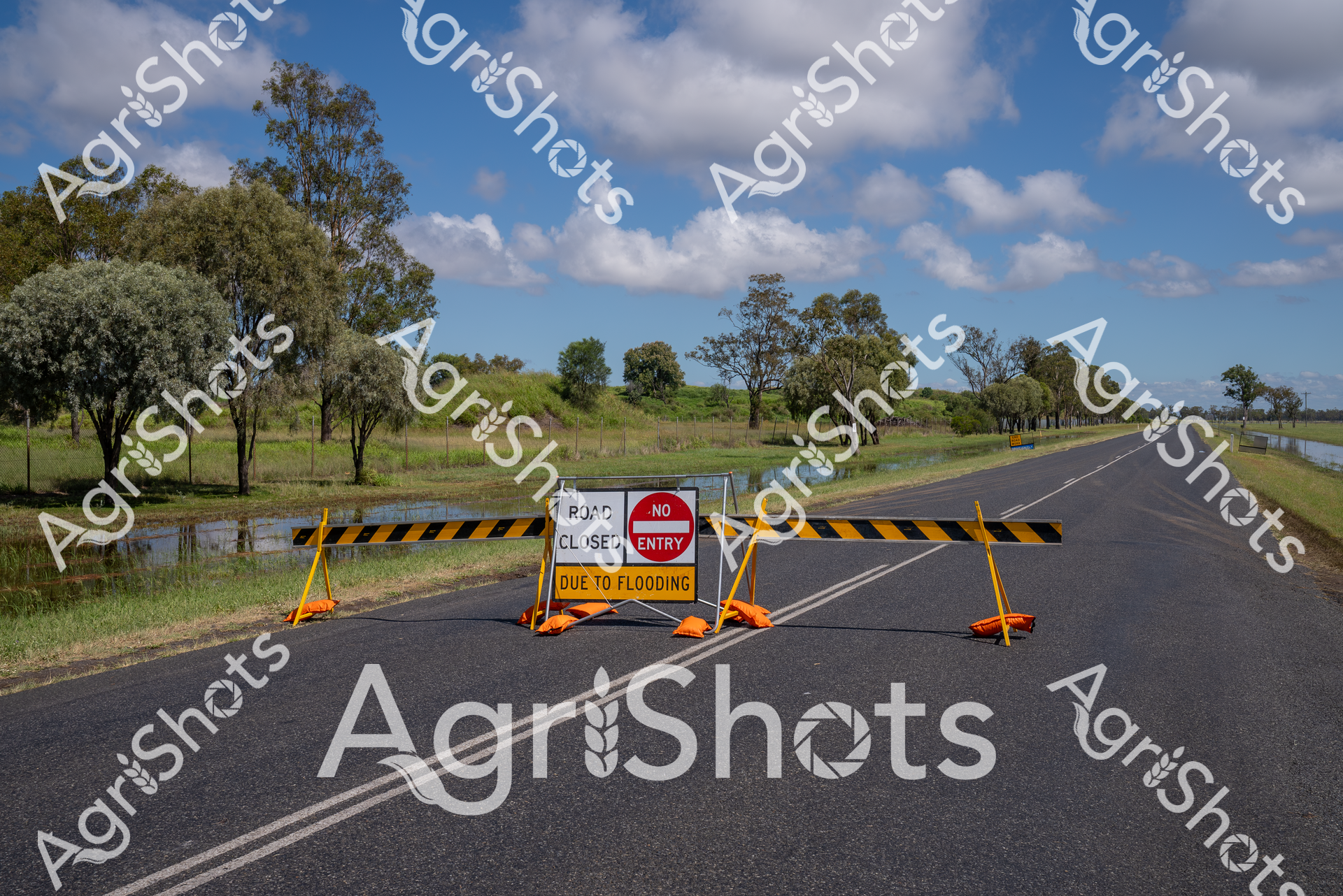
Rural Queensland Road Closure: Nature's Intervention Floodwaters have transformed this Darling Downs roadway into an impassable barrier, with stark yellow and black barricades blocking forward progress. Vibrant safety signage declares "ROAD CLOSED DUE TO FLOODING" and "NO ENTRY", creating a dramatic punctuation across the asphalt ribbon cutting through lush pastoral landscape. Expansive blue skies with billowing white clouds provide a stark contrast to the flooded grasslands and tree-lined roadside, where water pools alongside the bitumen surface. The yellow barricades and orange base supports stand in sharp relief against the grey road and green vegetation, highlighting the critical safety message during this natural event. Native eucalyptus trees stand sentinel in the background, their grey-green foliage a testament to the resilient Australian landscape that simultaneously nurtures and challenges agricultural communities. This image captures the unpredictable relationship between infrastructure and environment, where seasonal flooding can rapidly transform a straightforward rural thoroughfare into an unexpected obstacle.
 Image
Image
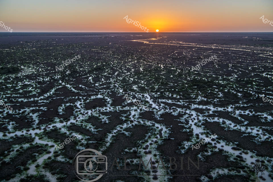
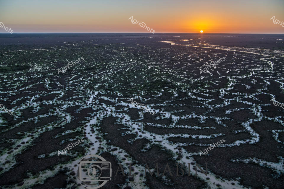
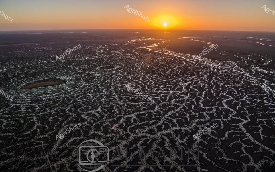
Golden Dawn over Channel Country Floodplains Sunrise bathes the expansive Channel Country landscape in ethereal light, revealing the intricate network of braided waterways and flooded grasslands characteristic of Queensland's remote western regions. Dark earth and silvery water intertwine in complex, vein-like patterns stretching to the horizon, creating a mesmerizing topographical tapestry that speaks to the dynamic hydrology of Australia's inland river systems. The early morning sun emerges as a perfect golden orb, casting warm amber and orange hues across a flat, seemingly infinite landscape that epitomizes the raw, elemental beauty of outback Australia. These seasonal floods are crucial for regenerating pastures, supporting livestock grazing, and maintaining the delicate ecological balance of this arid agricultural zone. The image captures the precise moment when dawn transforms the landscape, illuminating the water-saturated terrain with a luminous, almost ethereal quality that highlights the resilience and adaptability of pastoral ecosystems. This aerial perspective reveals the sublime complexity of Australia's inland waterways, where water is both a precious resource and a transformative environmental force.
 Image
Image
Ominous storm clouds gather over a waterlogged pasture in the Riverina, New South Wales, transforming the golden grasslands into a reflective inland sea. Scattered eucalyptus trees stand as silent sentinels, their branches etched against the steel-blue horizon, bearing witness to the dramatic seasonal flooding that has inundated the agricultural landscape. Shallow waters stretch across the paddock, creating a mirror-like surface that captures the turbulent sky and blurs the boundaries between earth and atmosphere. The scene captures the raw, unpredictable nature of Australian rural environments, where extreme weather can rapidly transform productive farmland into a temporary wetland. Soft grays and muted greens dominate the palette, with the standing water creating a complex texture of ripples, puddles, and submerged grass, highlighting the resilience of the agricultural ecosystem during challenging climatic conditions. This powerful image encapsulates the ongoing dialogue between land, water, and sky that defines the agricultural experience in rural Australia.
 Image
Image
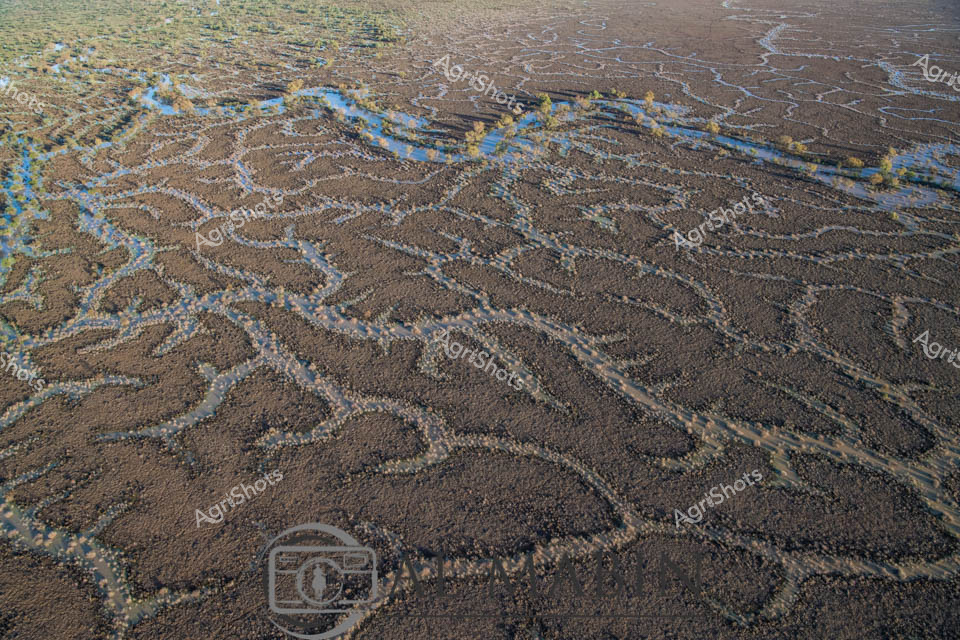
Serpentine waterways slice through the arid Channel Country landscape, revealing the intricate hydraulic networks of a Queensland cattle station during seasonal flooding. Sinuous blue channels meander across the brown earth, creating a complex arterial system that transforms the seemingly barren terrain into a dynamic, life-sustaining environment. The aerial perspective captures the remarkable geological patterns formed by water movement, with delicate blue streams branching and intersecting across the expansive, ochre-toned plains. These ephemeral water channels are critical to the survival of extensive beef cattle operations in this harsh central Queensland region, providing essential moisture and creating temporary grazing zones for livestock. The landscape demonstrates nature's extraordinary capacity to reshape and renew, with the flooding bringing crucial nutrients and regenerative potential to this remote pastoral ecosystem. The horizon stretches endlessly, revealing the immense scale of Australian agricultural landscapes where water management is a critical survival strategy.
 Image
Image
Serpentine waterways trace golden-brown earth like delicate veins across the expansive Channel Country landscape. Aerial perspective reveals the intricate network of ephemeral creek lines spreading across the arid Queensland landscape, where subtle green vegetation marks the moisture-rich pathways. The seasonal flooding has transformed the dusty plains into a complex hydrology of interconnected waterways, highlighting the dramatic seasonal transformations of Australia's inland pastoral regions. Windorah's distinctive landscape unfolds in earthy ochres and muted greens, showcasing the resilient ecosystem of remote western Queensland. Subtle variations in terrain create a mesmerizing topographic pattern, where water's ancient pathways carve intricate routes through the station country. The image captures the breathtaking scale and delicate ecological balance of Australia's inland water systems, where every rainfall and flood cycle reshapes the terrain in a timeless dance of renewal and survival.
 Image
Image
Turbulent pewter-gray clouds gather menacingly above the expansive Riverina floodplain, casting an ominous atmosphere over the waterlogged landscape. Recent summer storms have transformed the pastoral terrain into a reflective inland sea, with shallow waters stretching across the grasslands and pooling around sparse, resilient trees. A flock of sheep grazes stoically in the distance, their forms partially submerged, demonstrating the remarkable adaptability of livestock in this challenging environment. The flat horizon is punctuated by distant blue-tinged mountains, their silhouettes softened by the approaching storm front. Murky water reflects the dramatic cloudscape, creating a complex tapestry of grays, blues, and muted greens that speaks to the unpredictable nature of agricultural life in rural New South Wales. This powerful image captures the raw beauty and harsh resilience of the Australian agricultural landscape during a moment of natural transformation.
 Image
Image
Dawn breaks over Channel Country's mesmerizing landscape, revealing an intricate network of ephemeral waterways stretching across dark earth at sunrise. The braided creek systems of western Queensland glow with silvery-white ribbons of water, creating an extraordinary natural irrigation pattern that transforms the arid landscape into a complex hydological tapestry. Soft golden light crests the horizon, illuminating the serpentine water channels that wind through the dark soil, capturing the essence of this remote Australian inland ecosystem. These seasonal flood plains, characteristic of Queensland's western regions like Windorah, demonstrate nature's extraordinary capacity for water distribution across seemingly inhospitable terrain. The aerial perspective highlights the delicate balance of water and land, where each sinuous stream represents potential life and regeneration in this challenging agricultural environment. The image captures the raw, elemental beauty of Australia's interior - a landscape of extreme conditions where water is both rare and transformative.
 Video
Video
Thunderous storm clouds gather over a vast Riverina grassland, casting an ominous slate-grey palette across the expansive pastoral landscape. Scattered eucalyptus trees punctuate the flat, drought-stressed pasture, their silhouettes stark against the brewing meteorological drama overhead. A small mob of livestock - likely merino sheep or beef cattle - graze cautiously, their forms diminutive against the immense meteorological canvas. The grassland transitions from parched yellow-brown to muted green, suggesting recent minimal rainfall has sparked tentative regeneration. Turbulent cloudforms billow and churn, promising potential deluge, their layered textures ranging from deep pewter to soft charcoal, creating a dramatic atmospheric tension that speaks to the unpredictable climate of rural New South Wales. This raw video capture epitomizes the volatile beauty of Australian agricultural environments, where survival depends on reading the mercurial signals of impending weather systems.
 Image
Image
Aerial vista of Channel Country in remote Queensland, revealing the intricate natural water management system of an expansive cattle station. Sinuous waterways carve delicate, serpentine paths across an arid landscape, creating a mesmerizing network of silvery-brown channels that gradually transform the terrain from dusty grey to mottled green. The image captures the extraordinary resilience of this harsh inland ecosystem, where ephemeral creek systems bloom with subtle vegetation during rare flooding events, supporting critical pastoral operations. Soft blue skies stretch across the horizon, highlighting the immense scale of this agricultural landscape where water is the most precious resource. The winding channels demonstrate nature's engineering - gradually distributing scarce moisture across seemingly inhospitable terrain, enabling sparse but tenacious vegetation to emerge in intricate patterns. This breathtaking perspective from Al Mablin station showcases the complex hydrology of Australia's inland regions, where cattle stations must work in profound harmony with the unpredictable rhythms of water and land.
 Image
Image
Branching waterways weave an intricate network across the parched Channel Country landscape, revealing the ephemeral lifelines of Queensland's remote interior. Limestone-edged creek lines trace delicate golden-green pathways through ochre and umber plains, capturing the subtle hydrology of an arid pastoral ecosystem. During rare flood events, these seemingly fragile watercourses transform the landscape, carrying vital moisture across vast cattle station territories and sustaining native grasses that support extensive beef production. The aerial perspective unveils a natural irrigation system where water navigates subtle topographical contours, creating a mesmerizing organic pattern that speaks to the resilience of Australia's inland agricultural environments. Soft green vegetation clusters along the watercourse edges contrast with the dominant brown earth, highlighting the critical role of water in this unforgiving terrain. The Al Mabin watermark signals this as a professional agricultural landscape documentation, capturing the strategic beauty of Queensland's remote pastoral zones.
 Image
Image
Aerial rivers of blue snake through the parched ochre landscape of Queensland's Channel Country, revealing the intricate hydraulic network of seasonal waterways. Delicate blue threads trace sinuous paths across the arid brown terrain, creating an extraordinary natural map of water's ephemeral journey across this remote pastoral landscape. The floodplains display a remarkable geological tapestry, with meandering channels spreading like capillaries across the dry earth, capturing the dynamic relationship between water and land in Australia's inland regions. Soft yellow-green vegetation hints at the life-giving potential of these seasonal water courses, which transform the seemingly barren landscape into a complex ecosystem supporting cattle stations and native wildlife. The aerial perspective unveils nature's elegant engineering - a intricate network of waterways that appear almost like abstract artworks, revealing the hidden hydrology of this harsh yet beautiful inland terrain. This image captures the resilient spirit of Queensland's Channel Country, where water is both a precious resource and a powerful sculptural force shaping the landscape.
 Video
Video
Sweeping storm clouds gather over the Riverina's expansive agricultural landscape, casting dramatic slate-blue shadows across golden harvested paddocks. A sinuous river meanders through the foreground, its serpentine waters reflecting the turbulent sky and creating a lush green border between drought-stressed fields. Scattered eucalyptus trees punctuate the wide-open terrain, their weathered forms standing resilient against the approaching weather system. The aerial perspective reveals the delicate relationship between water and agricultural land, where seasonal extremes shape the farmer's constant negotiation with the environment. Distant mountains shimmer on the horizon, while the waterway suggests recent flooding has replenished the typically arid region. This raw, unedited video frame captures the raw beauty of Australian agricultural terrain - a landscape of perpetual transformation, where resilience and adaptation are written into every contour of the earth.
 Image
Image
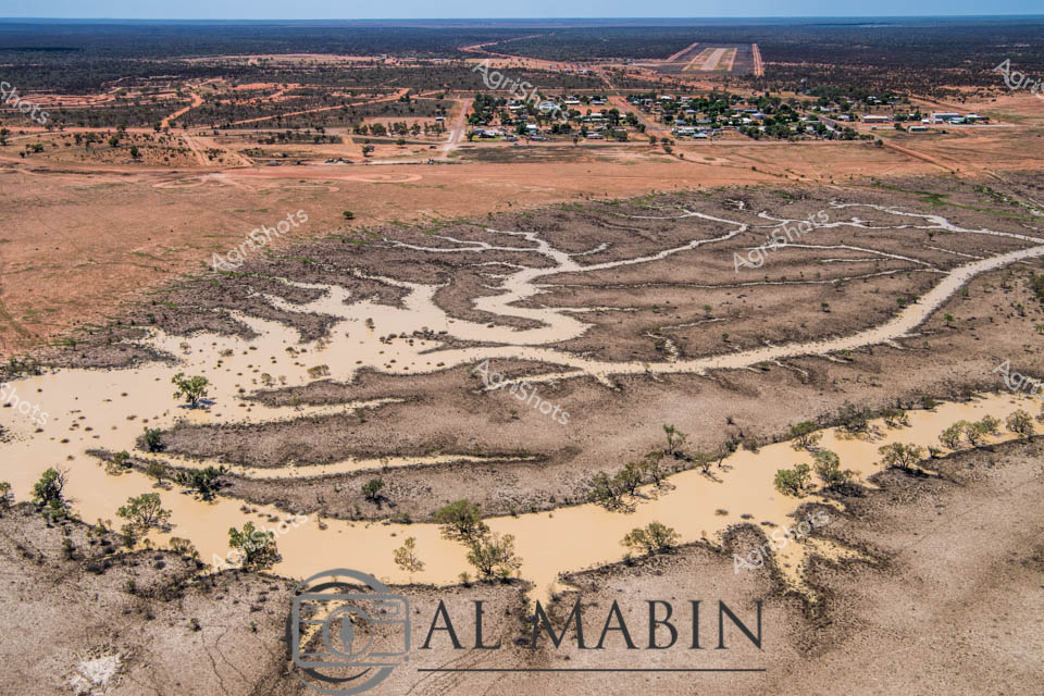
Aerial view of Al Mabin's Channel Country landscape near Windorah, Queensland, revealing the intricate dry riverbed and flood patterns of an arid pastoral region. The serpentine waterway winds through a dusty, ochre-toned landscape, its sandy banks punctuated by sparse, resilient eucalyptus trees that mark the natural contours of the creek system. In the distance, a small rural settlement clusters near a long airstrip, a lifeline for this remote beef cattle station where infrastructure is as sparse as the vegetation. The image captures the raw beauty of Australia's inland territories - a terrain sculpted by intermittent water flows, where each rare flooding event transforms the parched earth into a complex network of temporary rivers and channels. Subtle variations of tan, russet, and pale gold dominate the palette, highlighting the subtle textures of weathered ground and the delicate branching patterns of the dried watercourse. This landscape speaks to the resilience of Australian pastoral communities, who survive and thrive in one of the world's most challenging agricultural environments.
 Image
Image
Sunrise bathes the intricate waterways of Channel Country in a golden light, revealing the mesmerizing network of braided river channels stretching across the arid Queensland landscape. The aerial perspective captures the delicate, lace-like patterns of water threading through the dark earth, creating a stunning natural mosaic that defines this unique pastoral ecosystem. As the sun crests the horizon, its warm rays illuminate the complex hydraulic system that sustains life in this remote beef cattle production region. The waterways - likely Cooper Creek or a similar inland river system - demonstrate the critical importance of water management in Australian agriculture, showing how these ephemeral water networks support extensive cattle stations during both flood and drought conditions. The intricate branching channels reflect the resilience of the landscape, with each silvery stream potentially representing a lifeline for cattle grazing in this challenging environment. This breathtaking vista encapsulates the raw beauty of Queensland's inland pastoral zones, where water is the most precious resource in a seemingly inhospitable terrain.
 Image
Image
Golden wheat stretches across the undulating paddock, its ripe heads bowing under the intense summer sun of New South Wales. A brilliant green John Deere header moves purposefully through the field, kicking up a billowing cloud of dust that dances against the backdrop of scattered eucalyptus trees and a soft blue sky. The wheat's uniform golden-brown texture creates a mesmerizing landscape of agricultural precision, revealing the careful cultivation of this critical grain crop. Harvesting is in full swing, with the header methodically cutting and collecting the wheat, transforming the ripened field into a patchwork of cut and uncut sections. The machinery moves with mechanical grace, a testament to modern agricultural technology that allows farmers to efficiently gather their season's yield under the expansive Australian rural landscape. The scene captures the essence of Australian agricultural productivity - a moment of transformation where months of careful nurturing culminate in the critical harvest season.
 Image
Image
Golden waves of mature wheat ripple across a vast paddock under a soft blue summer sky, punctuated by scattered gum trees on the horizon. A gleaming green John Deere harvester moves methodically through the field, generating billowing clouds of dust as it cuts and processes the ripe wheat crop. The wheat's rich golden-brown hue contrasts beautifully with the verdant machinery, capturing the essence of Australian agricultural productivity during harvest season in rural New South Wales. Precision agricultural techniques are evident in the systematic path of the header, demonstrating the sophisticated approach to crop management in this expansive dryland farming landscape. Subtle textures reveal the wheat's ripeness - slightly bent and ready for harvesting, with clean cuts marking the harvester's progress through the dense field. The scene embodies the quiet determination of Australian farmers, transforming endless acres of golden grain into a critical global food resource under an open, promising sky.
 Image
Image
Golden wheat stalks stretch across the panorama, their amber waves interrupted by a serpentine blue waterway cutting through the mature crop. Flood damage reveals the challenging environmental conditions facing Australian grain farmers, with water pooling between dense wheat rows under a serene blue sky punctuated by soft white clouds. The landscape speaks to the resilience of agricultural practice in New South Wales, where summer's intense conditions can rapidly transform a promising harvest. Trees line the distant horizon, creating a natural boundary that frames the agricultural tableau, their green canopies contrasting with the ripened wheat's rich golden hues. This scene captures the delicate balance between agricultural aspiration and environmental unpredictability, where water's destructive potential intersects with carefully cultivated farmland. The image embodies the silent drama of rural agricultural landscapes - a testament to the ongoing negotiation between human cultivation and natural forces.
 Image
Image
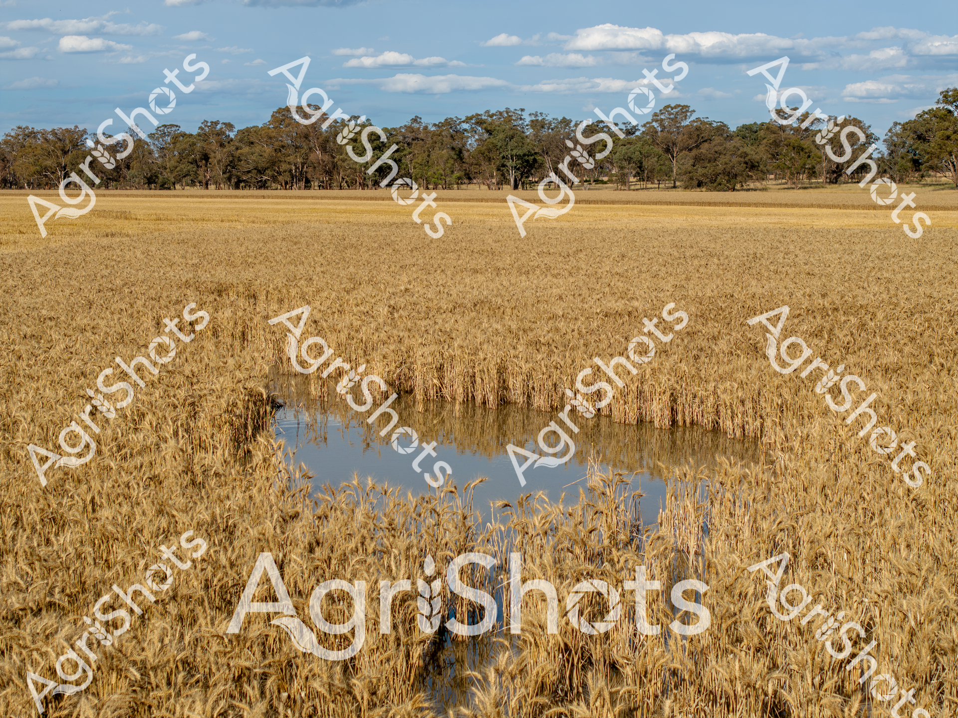
Golden wheat stalks rise from water-logged ground, creating a stark contrast between agricultural abundance and environmental challenge. Recent flooding has partially submerged a mature wheat field, with the golden grain heads still visible above the reflective blue water. Scattered eucalyptus trees line the distant horizon, typical of a New South Wales agricultural landscape, under a soft blue sky dotted with wispy clouds. The scene captures the resilience of Australian farming, where crops must withstand unpredictable environmental conditions. Mature wheat plants stand partially underwater, their rich amber tones reflecting in the still surface, demonstrating both the vulnerability and adaptability of dryland farming systems. The image embodies the delicate balance between agricultural production and natural water cycles, a narrative deeply embedded in the Australian rural experience.
 Video
Video
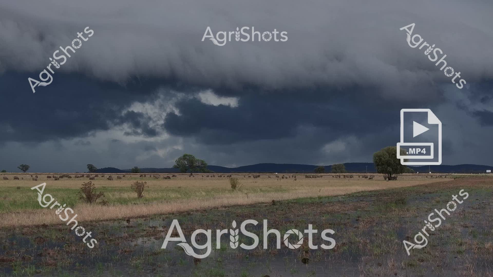
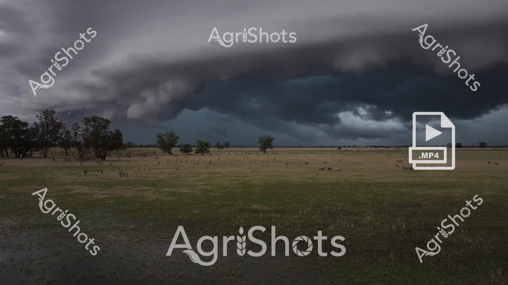
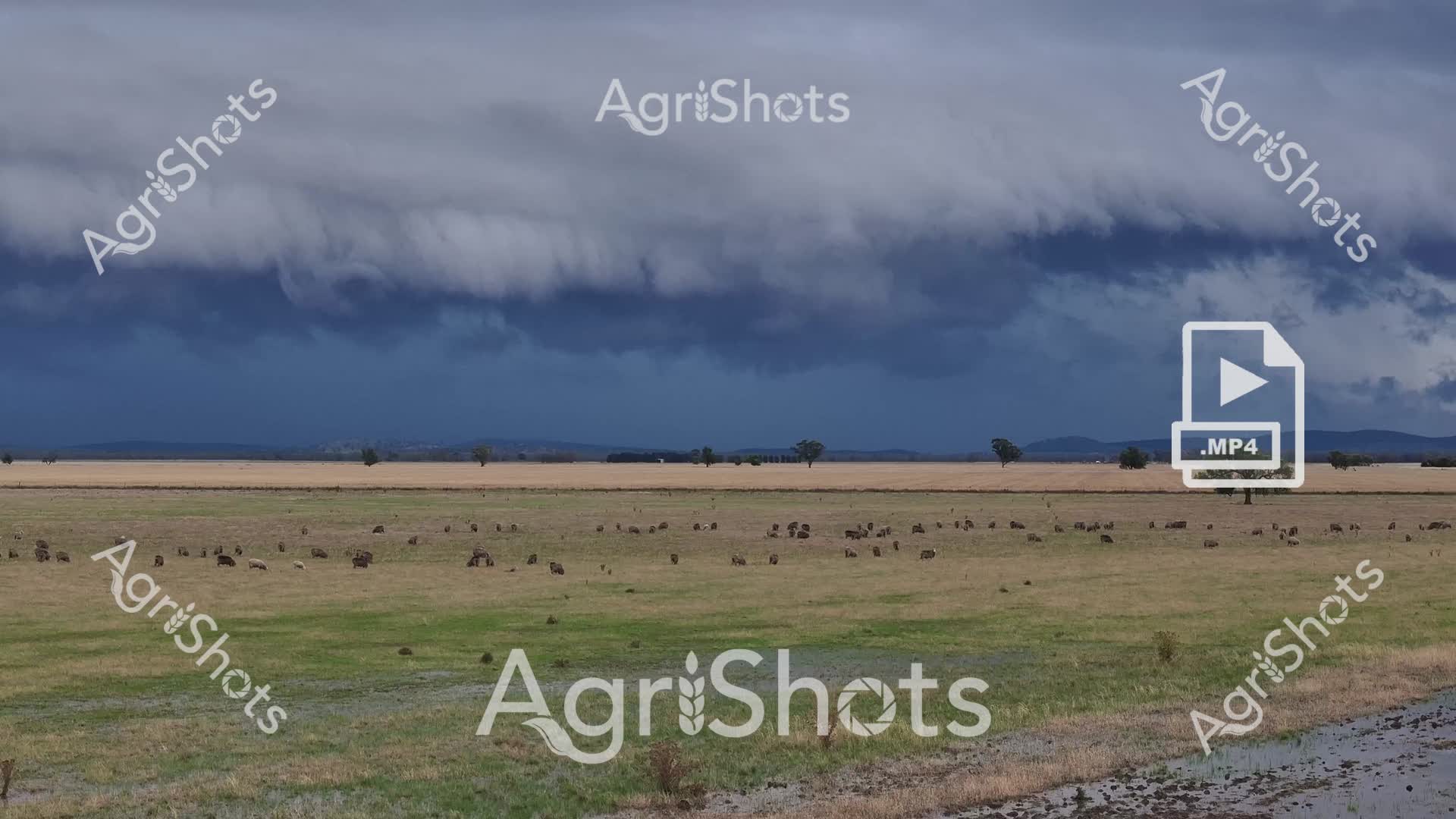
Turbulent storm clouds gather over the expansive Riverina grasslands, casting a moody slate-blue shadow across a sea of grazing livestock. The paddock stretches toward distant mountains, dotted with hundreds of robust merino sheep grazing methodically across verdant and golden pasture zones. A dramatic weather system builds on the horizon, promising imminent rainfall - the landscape charged with atmospheric tension and the potential for sudden transformation. Floodplain grasses transition from deep green to pale straw colors, indicating late summer or early autumn conditions typical of New South Wales agricultural regions. Scattered eucalyptus trees punctuate the distant treeline, providing sparse shelter against the approaching storm front. The raw, unfiltered MP4 video format captures the dynamic environmental conditions, preserving the dramatic interplay between pastoral landscape and powerful meteorological forces.
Well, you've ploughed through the whole field!
No more crops to harvest here, mate.
Try searching for something else in our library of 50,000+ royalty-free media: